|
| Woods,
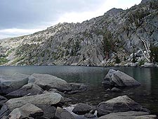
Round Top & Winnemucca Lake Loop 08/19/04 Location: Mokelumne Wilderness - Near Tahoe, CA Distance: 4.8 miles loop (3+ hours) Difficulty: Easy/Moderate Elevation gain: Approximately 1200 feet Of all the hikes I've been on in the Lake Tahoe area, this is by far one of the prettiest. Near to the Kirkwood Ski Resort, the trail head is only about 20 mins out of South Lake Tahoe and worlds away from all the heavy tourist traffic. At an elevation of about 8,000 feet, you will still find good sized patches of snow well into the end of August. In fact, the absolute best time to be up here is from about mid July through mid August where it's basically spring time and the wildflowers are in full bloom. Please be sure to pack plenty of water and be sure to pack a rain shell. My family started off on this trail to what would otherwise seem like a beautiful sunny and hot day.... but that changed within minutes as a thunder cloud came overhead and gave us a good shower. How to Get There From South Lake Tahoe, take Highway 89 south and then head west on Highway 88. Approximately 2 miles west of Carson Pass, you should see a road to the south that is well marked with a National Forest sign indicating Woods Lake Campground. Turn on to this paved road and follow it to the trail head parking lot. There is a very clean pit toilet facility here and parking is $3 per vehicle. From the parking lot, cross the concrete bridge and you will find the trailhead to your right. Follow this trail until you come to a fork indicated by a trail marker. Stay to the right (Round Top Lake Trail) and head up to Round Top Lake. Within about a mile, you will come up to a great view of Woods Lake and some old buildings of the Lost Cabin Mine. Even though this mine hasn't be worked in about 40 years, the claim is still active and there are signs posted everywhere letting you know. Further up the trail, you will find some more mining equipment as well as the remains of what looks like an old Ford Model T. At about 2 miles, you will come up to Round Top Lake. There will be a wooden post indicating the direction to 4th of July Lake to the south and Winnemucca Lake to the east. Before you continue on, you might want to stop here for a while and take in the beauty. The view of Round Top Lake with the magnificent backdrop of the Sisters and Round Top peak was so impressive that my family and I decided to take a break here and do lunch. If you're really feeling adventurous, there is a steep one way trail that'll take you right up to the top of the 10,381 foot Round Top peak!! Back on the trail, head east for about a half mile and you will find yourself at Winnemucca Lake. Like Round Top Lake, the water is crystal clear here and surrounded with large granite boulders. From here, continue to follow the trail north (Winnemucca Lake Trail) and it will be all down hill and easy hiking from here. At about a mile down, you will be back under the tree line and back down at Woods Lake in about 2 miles. If you couldn't tell by now, I'm not big up on crowds so we decided to bypass Woods Lake and continued on across a newly constructed wooden bridge and then back to the parking lot. Click here to see more photos from our trip Please let me know if you have any questions. |
   |


